TurQuosian

Southeastern Türkiye

Nemrut

Toppled gods, watched at dawn and dusk

Nemrut is a mountaintop, not a town: colossal carved gods and a king, toppled by earthquakes, arranged for sunrise on one terrace and sunset on the other. This is a genuinely low-traffic corner of Türkiye — base yourself in Kahta, the small district town closest to the summit, not Adıyaman or Malatya. The summit road is snowbound for real stretches of winter, roughly December to March.

Stay
2 days
Best months
May–Jun, Sep–Oct
Elevation
2,150m
Airport
ADF

Every published place in one city guide

What to see in Nemrut.

Start with the essentials, add what genuinely interests you, and leave the rest for another visit. Every place includes a concise story, practical timing, a Maps link, and a one-tap route planner action.

Make the route work

Anticipate the practical details.

Getting there

There's no airport in Kahta itself. The regional option is Adıyaman Airport (ADF), with a limited schedule — direct flights only to Istanbul and Ankara, not a hub reachable directly from abroad. Most travellers connect through Istanbul and fly or bus onward. The overland option is real but long: intercity buses put Istanbul–Adıyaman at around 19 hours. From Adıyaman, dolmuş and onward transport reach Kahta, about 34km away.

Getting around

Base yourself in Kahta and expect to drive yourself or join an organised tour — there's no public transport to the summit car park. The southern approach through Karadut is paved and is the standard route; a longer northern approach from Malatya climbs over Pütürge and Tepehan instead. Both are affected by the same winter closure: the summit road is regularly snowbound from around December through March, reopening on a date that moves every year with the thaw. Arsameia, Cendere Bridge and Karakuş Tumulus sit lower, on the same road corridor from Kahta, and are normally done together as one loop, separately from the summit run.

Money

Carry a payment card and some Turkish lira — this is a small local economy, not a resort strip. The summit entrance fee is genuinely unclear at the time of writing: reported figures range widely and don't agree with each other even allowing for currency movement, which suggests some are stale. Confirm the current fee at the gate rather than trusting an older listing. Museum Pass Türkiye (Müzekart) is reported to be accepted, though not guaranteed.

Connectivity

This is a remote, low-density rural area by Turkish standards, and mobile coverage on the mountain road and at the summit itself is inconsistent. Download offline maps in Kahta before heading up, particularly if you're driving yourself before dawn.

Etiquette

Nemrut is an active UNESCO World Heritage site and an ongoing archaeological conservation project — don't climb on the statues or the fallen heads for photographs, and respect any barrier you find, including informal ones. Southeastern Türkiye more broadly is conservative outside the tourist sites themselves; modest dress is appreciated in the towns along the way.

Safety and comfort

The summit sits at 2,150m and is genuinely cold and windy even when the valley towns below are hot — bring a real layer whatever the season. The mountain road closes for real stretches of winter under snow; don't plan a December–March trip around reaching the summit without checking current conditions first. This region was hit hard by the February 2023 earthquake, and reconstruction is still visibly ongoing in places — part of the reasoning behind recommending Kahta over Adıyaman city centre as a base, and worth knowing if your plans extend beyond this page. Check your government's current travel advisory for southeastern Türkiye before booking.

Essential

Don’t leave without

If you only have one day, this is the day.

Rank1
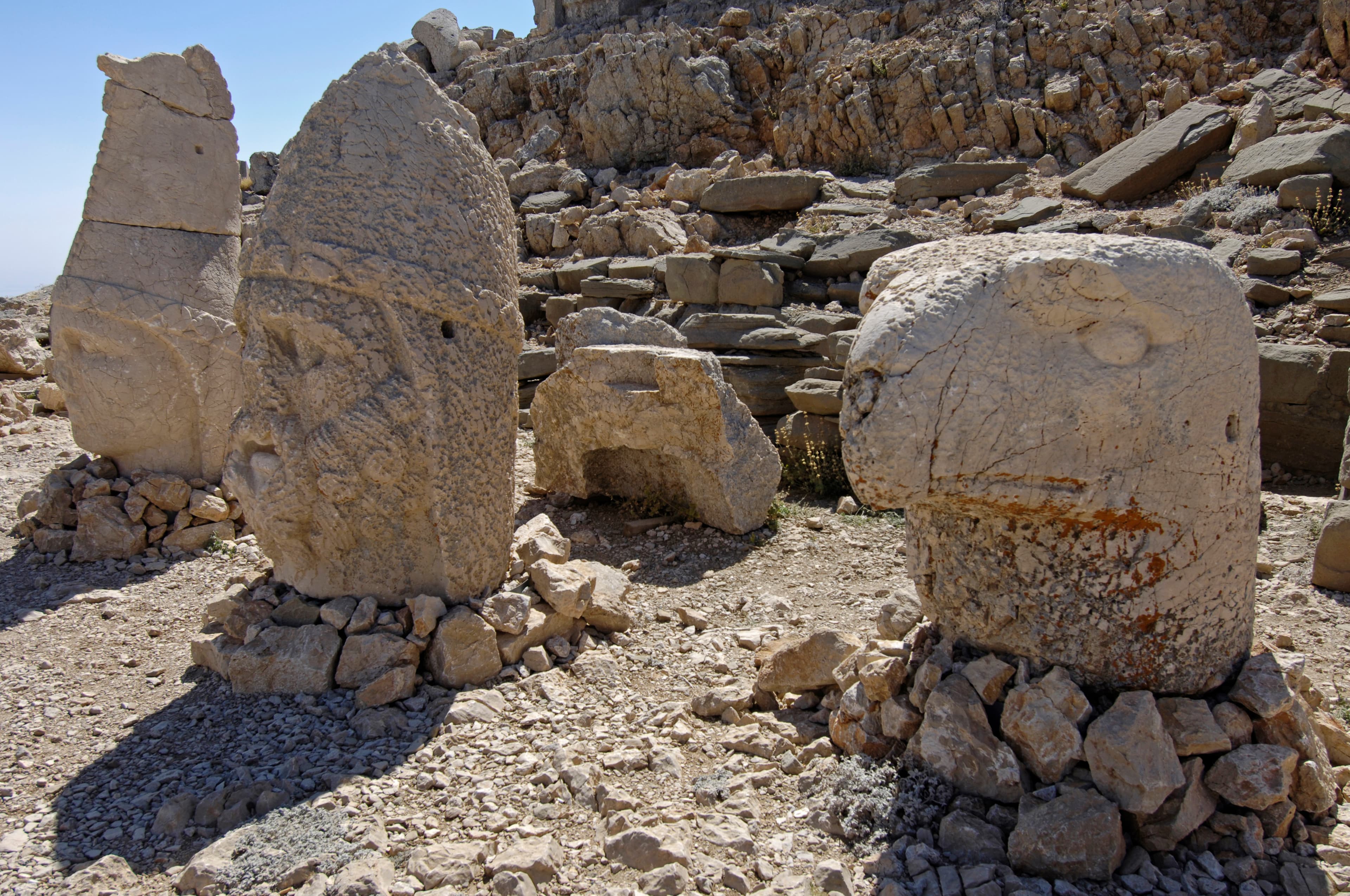
Row of colossal weathered stone heads on rubble at Mount Nemrut's East Terrace summit

East Terrace

Archaeological site

Five colossal gods, heads knocked to the ground by earthquakes, still seated to greet the one sunrise this mountain was built to frame.

Antiochus I of Commagene raised this, the more sacred of his mountain's two terraces, around 62 BCE. Five seated figures — himself, Zeus-Oromasdes, Apollo-Mithras, Herakles-Artagnes, and the goddess Commagene — stood 8–10m tall, flanked by a lion and an eagle. Only the heads have fallen. Karl Sester found the site in 1881; Theresa Goell led the first dig from 1954. The tomb itself has never been found.

35 minThe classic sunrise plan means leaving Kahta around 2–3am in the dark, and the summit sits in cloud often enough that a clear sunrise is a bonus, not a guarantee.The summit road is snowbound for stretches of winter, typically December through March; the exact reopening date shifts year to year with the spring thaw.No shelter at 2,150m, and it is genuinely cold and windy up here even when it's hot in the valley towns below — bring a real layer regardless of season.
+1 more to know
An active five-year conservation and stabilisation project began on the statues in 2025; expect some conservators or light equipment on site.
Look for: The inscription carved into the backs of the thrones — Antiochus's own account of why he built this. The stepped altar in front of the fallen heads, and the lion and eagle guardians at each end of the platform.
Verified · · 4 min to West Terrace
Rank2
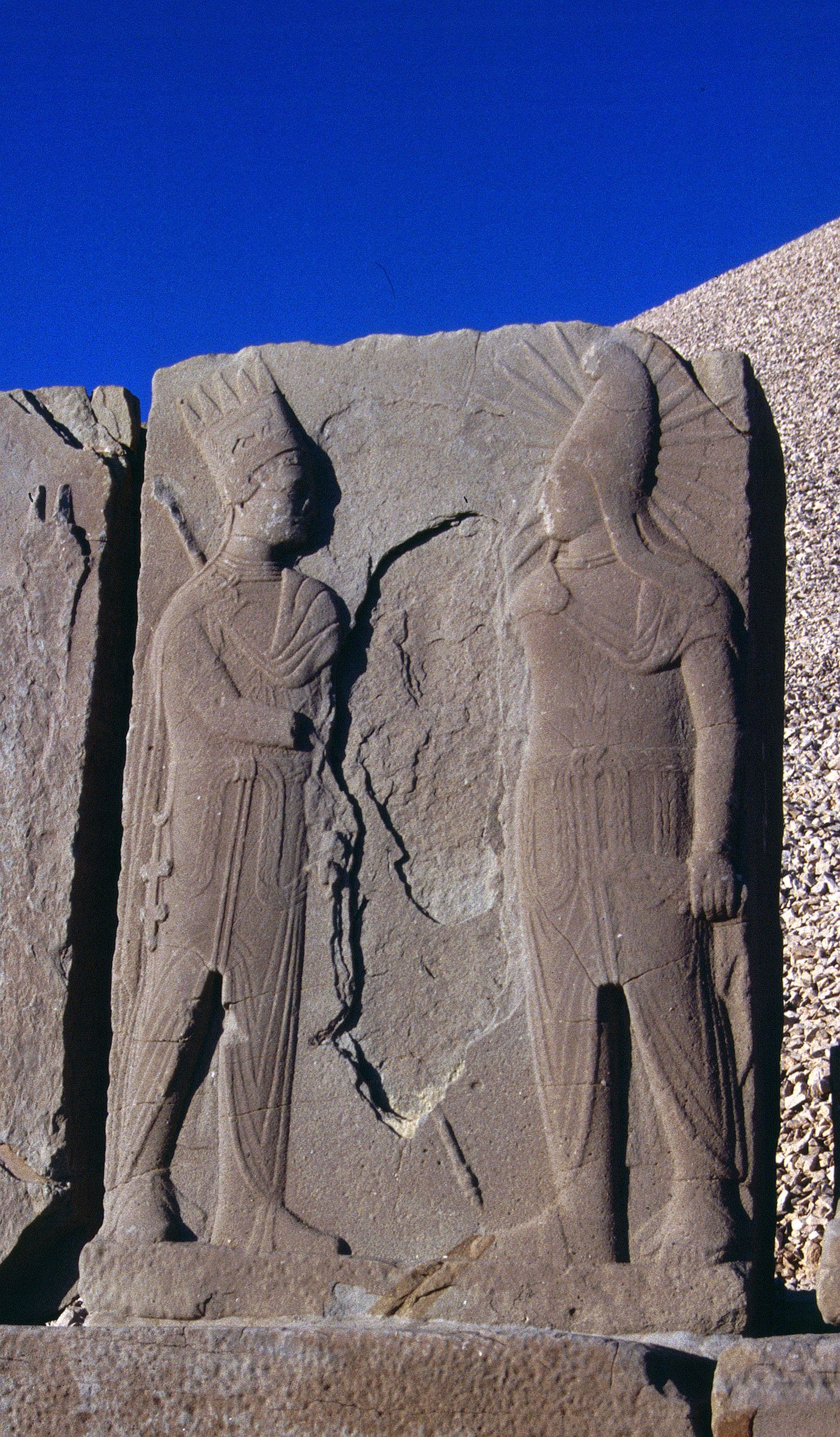
Well-preserved dexiosis relief of two royal figures shaking hands, Nemrut's West Terrace

West Terrace

Archaeological site

Sunset on the same fallen gods, plus the Lion Horoscope — a carved star chart that may date construction to 7 July 62 BCE.

Narrower and more damaged than its eastern twin, though the individual heads survived in better condition. Five statues stand only about 2m up, facing the sunset; there is no altar. Three dexiosis reliefs show Antiochus clasping hands with Apollo, Zeus and Herakles. The Lion Horoscope slab reads as a sky chart — Jupiter, Mercury and Mars beside a crescent moon and stars — fixed to 7 July 62 BCE.

30 minSame winter road closure as the rest of the summit, roughly December to March, with a reopening date that shifts year to year.Sunset tours arrive later in the day but still mean driving the mountain road in the dark on the way back down to Kahta.The Lion Horoscope and dexiosis reliefs are exposed carved stone at 2,150m; touching and climbing on them for photographs is both damaging and discouraged by site staff.
+1 more to know
No shelter at the summit, and conditions can shift quickly even on a clear afternoon.
Look for: The Lion Horoscope relief, and the three hand-clasp (dexiosis) scenes beside it. The unfinished stelae along the short causeway around the north side of the tumulus, where almost nobody stops.
Verified · · 4 min to East Terrace

Worth your time

Worth your time

A second day earns you these.

Rank1
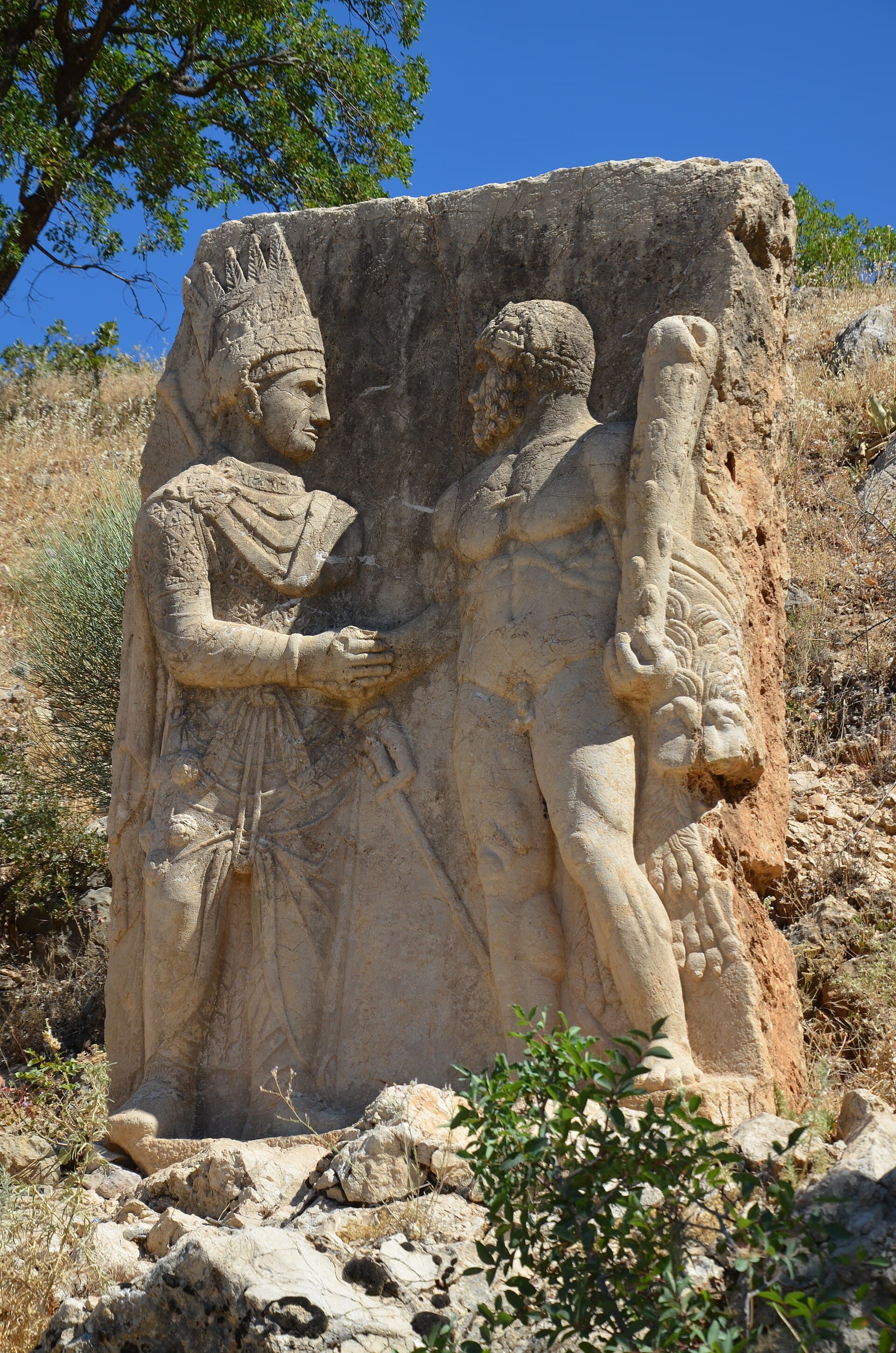
Rock-cut relief of a king clasping hands with the nude god Herakles at Arsameia

Arsameia

Archaeological site

The kingdom's clearest carved handshake between king and god, one generation older than the summit — most people driving past skip it.

Antiochus I built this hierothesion for his father, Mithridates I Callinicus — a smaller, earlier echo of the sanctuary he later raised on the summit. A rock-cut relief shows a king clasping hands with a naked Herakles. Beside it runs a Greek inscription, among the longest to survive from antiquity. A tunnel cut into the rock descends roughly 150m for a purpose nobody has explained.

45 minThe rock-cut tunnel beyond the inscription is unlit; visitors who want to go past the entrance need their own light source.Signage is minimal and the marked points are reached by an uphill scramble on rough ground rather than a paved path.Often visited in a rush on the way to or from the summit — budget the 45 minutes properly rather than treating it as a two-minute photo stop.
Look for: The dexiosis (handshake) relief itself, and the inscription cut into the rock beneath it. Past the second marked point, the mouth of the rock-cut tunnel — bring your own light if you want to go beyond the entrance.
Rank2

Cendere Bridge

Historic site

A Roman bridge from around 200 CE, still standing on one stone arch — the longest span of any surviving Roman arch bridge.

Built by the Sixteenth Legion, stationed at Samosata, in honour of Septimius Severus and his family. Four Corinthian columns originally stood at its ends, one for the emperor, his wife Julia Domna, and their two sons; three still stand. Restored in 1997 and closed to vehicles once a new road bridge opened 500m downstream — it had carried traffic continuously since it was built, until then.

20 minClosed to vehicles since a modern bridge was built alongside it — you cross this one on foot only.A working roadside stop with a tea garden rather than a managed heritage site; there's no ticket booth or formal visitor infrastructure.
Look for: The single 34m arch, and the three surviving columns — count them and notice which end of the family is missing one. A small roadside tea garden sits by the bridge, a genuine local gathering spot rather than a tourist café.
Open in Maps

If you have longer

If you have longer

Keep these compact stops in mind when you build your trip.

Karakuş Tumulus

Archaeological site

Mithridates II of Commagene, Antiochus I's son, built this hierothesion around 30–20 BCE for the kingdom's royal women: his mother Queen Isias and two princesses. Three groups of tall Doric columns once stood on the mound, each topped with a different animal — bull, lion, eagle. Looted after Rome annexed the kingdom in 72 CE, and reportedly damaged again by the February 2023 earthquake that struck this region hard.

One of the tumulus's columns was reported down after the February 2023 earthquake; treat its exact current condition as unconfirmed until you're there, and re-check before publishing.A quick roadside stop with little formal infrastructure — no shade and minimal parking.
20 minOpen in Maps

Getting there and away

Verified routes from Nemrut.

Door-to-door times and fare ranges, checked leg by leg. Only routes where every leg verified are listed.

Getting around

Türkiye, for scale

Where it sits

See this city in the wider shape of Türkiye.

The map will load as it approaches the viewport.